Tarakihi (NZ Maori), Ocean Bream (NZ)
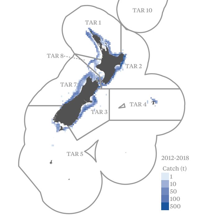
Tarakihi are caught by commercial vessels in all areas of New Zealand from the Three Kings Islands in the north to Stewart Island in the south. The major fishing grounds are west and east Northland (QMA 1), the western Bay of Plenty to Cape Turnagain (QMAs 1 and 2), Cook Strait to the Canterbury Bight (mainly QMA 3), and Jackson Head to Cape Foulwind (QMA 7).
The main fishing method is trawling. The major target trawl fisheries occur at depths of 100–200 m and tarakihi are taken as bycatch at other depths as well. Around the North Islands 70–80% of the tarakihi catch is targeted. Around the South Island only about 30% of the tarakihi catch is targeted; with much of the remainder reported as bycatch in target barracouta and red cod bottom trawl fisheries. There is a commercial minimum legal size set for all tarakihi stocks at 25 cm.
Tarakihi is managed by Fisheries New Zealand using the Quota Management System (QMS).
The risk assessment for tarakihi is currently under review.
The risk assessment framework is used to assess the relative environmental risks of Australian and New Zealand wild-caught fisheries on fish stocks and the aquatic environment.
Assessments are undertaken for each species according to multiple ‘units of assessment’ (UoAs). The UoA is a combination of target species/stock and the gear type used by the fishery. Each UoA is assessed against three components for target species, bycatch and ecosystems, and management systems. Each component has a number of performance indicators, which have associated criteria, scoring issues, and scoring guideposts. For each UoA, each performance indicator is assigned a risk score according to how well the fishery performs against the scoring guideposts.
The risk assessment framework is currently under review and new risk assessments will be available soon.


Risk Assessment Summary

The risk assessment for tarakihi is currently under review.
